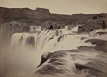
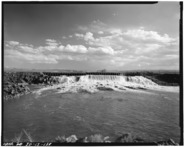
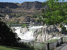
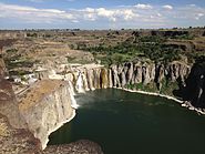
The fifth stop in our series Off the Beaten Path brings travelers to Shoshone Falls located in Idaho, which is a waterfall on the Snake River in southern Idaho, located approximately 3 miles northeast of the city of Twin Falls.
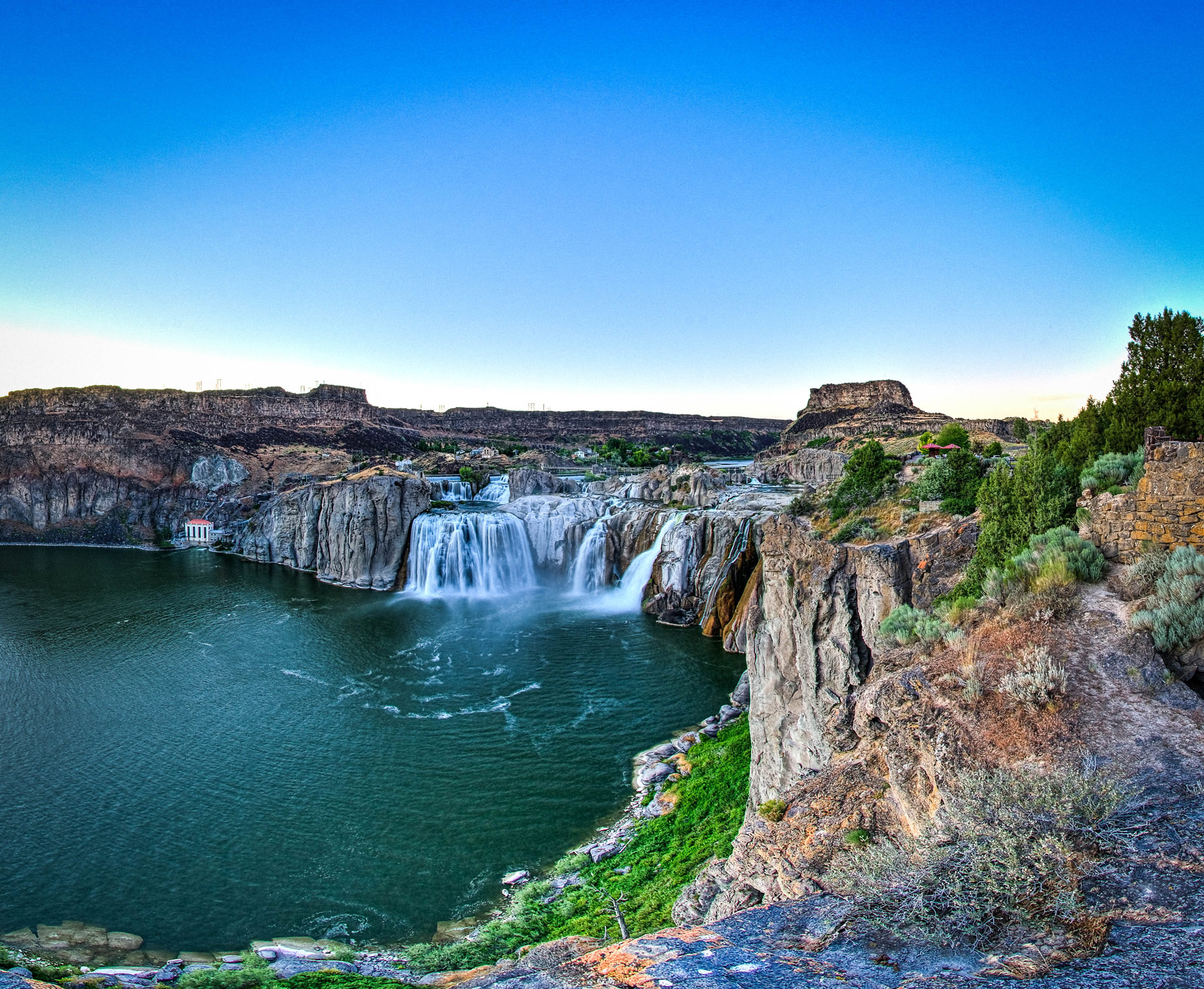
Photo credit: Visit Idaho.com.
The waterfalls are part of the Snake River and are sometimes referred to as the Niagara of the West. Shoshone Falls is 212 feet (65 meters) high, which is 45 feet higher than the far more famous Niagara Falls.
Shoshone Falls flows over a rim between 900 and 1,000 feet (300m) wide. It is one of the largest natural waterfalls in the United States. It is located outside the city of Twin Falls.
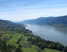
The Columbia River Gorge facing east toward Beacon Rock.
The water flows over the falls are comprised of the seasonal runoffs from the Snake River. Over the years the force of erosion and floods, has carved its way through the various canyons and ravines, as the largest tributary of the Colombia River makes its way west.
Being located in an arid region, Shoshone Falls naturally receives most of its water from snow melt in the Rocky Mountains of Idaho and Wyoming. The watershed is near Yellowstone and the Grand Teton National Parks and to a lesser extent, a number of springs in the Snake River Canyon above the town of Twin Falls.
The Snake River
The place drew national attention in 1974, when the American daredevil Evel Knievel made an unsuccessful attempt, to jump over Shoshone Falls to a crowd of 30,000. He survived the dangerous stunt after nearly drowning.
Shoshone Falls are named for the Lemhi Shoshone or Agaidika people, so named because of their consumption of salmon. They descended on the area near the falls, because of the immense salmon runs in the Snake River.
The Bannock people also traveled to the Shoshone Falls each summer, to gather salmon and to trade.
The noteworthy Expedition by Lewis and Clark, during the years 1805 to 1806 did encounter the Shoshone, but did not pass through the Falls area.
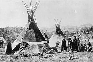
A Shoshone encampment in the Wind River Mountains of Wyoming, photographed by W. H. Jackson, 1870
The 1811 Wilson Price Hunt Expedition, looking for new routes to assist the growing fur trade, were traveling on the Snake River, at least as far as the present-day American Falls.
They did not make it to Shoshone Falls, because of the increasingly unsafe conditions of the river. The members of this party turned back, at a place they called the Devils Scuttle Hole.
The route they set would become part of the famous Oregon Trail, which would facilitate the eventual arrival of migrants, from the eastern part of the United States to the area of the Falls. Some early settlers named the cataracts Canadian Falls. It is still not clear where this moniker originated from.
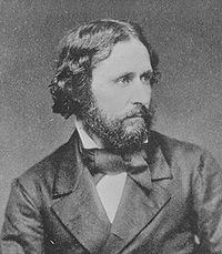
John C. Fremont an American military officer, explorer, and politician.
In the 1840’s John C. Fremont would pass by Shoshone Falls. In his now famous 1843 expedition, in which he attempted to map the western portion of the Oregon Trail, he would name the cataracts the Fishing Falls.
He further added that the salmon were so abundant, that the Shoshone could throw their spears at random and still catch the tasty fish.
The Shoshone encounters with Americans were generally friendly, but would later end in conflict over land ownership. After the Bear River Massacre of 1863, the Shoshone were forced onto reservations.
There would be a Geological Exploration in 1868. The director of the survey Clarence King, would be the first to suggest, that the canyons and falls might have been created by a great catastrophe, rather than forces of slower paced regular erosion.
Shoshone Falls and the Snake River Canyon as it appeared before damming, photographed by Timothy H. O’Sullivan, circa 1874
Thomas H. O’Sullivan also on this expedition, is the first known person to photograph the falls. He would later return in 1874, for a second photography trip.
Despite barren and isolated surroundings, Shoshone Falls still managed to become a major tourist attraction from the mid-19th century onward. The reason for this was the close proximity it had to the Oregon Trail. Only a slight deviation to the north, was necessary to see the Falls.
By the 1860’s it was already being referred to as The Niagara of the West. The falls would become even more famous, once they were painted by Thomas Moran, well known for his depictions of Western landscapes.
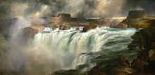
Shoshone Falls on the Snake River by Thomas Moran, c. 1900
The discovery of gold in the Snake River Canyon during 1869, would bring a rush and subsequent boom that would end rather quickly, as local geology made mining somewhat difficult.
It was in 1876, that Charles Walgamott as a local homesteader, finally saw the true potential of Shoshone Falls as a tourist destination. He would later start the construction of the first lodge for visitors.
In 1883, the Oregon Short Line Railroad would be extended to Shoshone, Idaho making traveling to the falls far easier. The true isolation of the place, had at last ended.
Milner Dam
The vast Snake River Aquifer is a creation of the region’s porous volcanic rock and gets recharged every year, by the melting snows throughout this mountainous area.
Since the Shoshone Falls canyon lies lower in elevation than the surrounding terrain, groundwater is forced to the surface, through the motion of large springs located throughout the canyon walls.
Even though Milner Dam can often divert almost all the water up stream, these canyon streams can provide up to 3,000 cubic feet per second of water to the falls. Flows can vary according to the season, although it has increased since the 1950’s, due to the irrigation water on the surrounding land trickling into the aquifer.
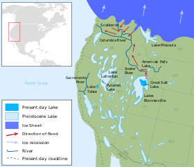
Map of Pleistocene lakes in the Western US, showing the path of the Bonneville Flood along the Snake River.
Shoshone Falls was formed by a catastrophic outburst of water, known as the Bonneville Flood at the end of the last ice age, that geologists refer to as the Pleistocene. This is estimated to be between 14,500 and 17,500 years ago.
Sometime during that period the immense freshwater lake known as Lake Bonneville that covered much of the Great Basin, overflowed through the Red Rock Pass and into the Snake River.
At that time about 1,100 cubic miles, the equivalent of 4,600 km3 of water was released. This is 1,500 times the average annual flow of the Snake River at Twin Falls. This incredible flow of water carved the entire Snake River Canyon in a matter of several weeks.
During this dramatic event, a number of local geographic features would be created, including Shoshone Falls, where the local geology interacted with the much harder underlying rock layers.
Shoshone Falls Dam, located directly above the falls, diverts water for hydro-power generation and can greatly reduce the flow of the falls in the dry season.
The Falls mark the historical upper limit of fish migration in the Snake River. This would include the commercially important salmon. The entire region remained an essential fishing and consequently trading place, for native tribes of the Americas for numerous millennium.
Shoshone Falls was already being mentioned by Americans and Europeans as early as the 1840’s, despite the isolated location of the site.
Within the next 20 years it had become a tourist attraction, although it was not easy to access during those early days.
In the early 20th century, the Snake River became a primary contributor to economic development in southern Idaho. The irrigation diversion for the Magic Valley and hydroelectric power plants, built right above the falls, provided the needed resources for an influx of settlers.
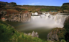
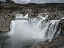
Shoshone Falls high flow of about 20,000 cubic feet per second (570 m3/s) in June 2011
These alternative uses of the water were quite controversial, because it greatly reduced the amount of water available to Shoshone Falls. This greatly impacted tourism, especially during the dry season.
As a result, this makes a trip to the Falls a seasonal event, if you wish to view the cataracts at their full potential. Peak water flows can be expected between the months of April and July. Many travelers recommend May and June as the ideal months for a visit.
The seasonal variation is quite dramatic. The water flow over the falls ranges from 20,000 cubic feet per second during late spring of wetter years, to a minimum 300 cubic feet per second in dry years.
Water is often released from the dams ahead of the falls, to ensure what is known as a scenic flow. Shoshone Falls has become a major tourist attraction for the area and therefore, water is discharged periodically for that specific purpose.
A nearly dry Shoshone Falls on July 7, 2013
Idaho Power’s Dam which is upstream from the falls, is required to provide this minimum flow of water from April through Labor Day in early September.
The multipurpose use of the waters of the Snake River, makes the various stakeholders competitive for a scarce resource.
The water diverted to the Shoshone hydroelectric plant for example, continually reduces the water flow throughout the year. The facility requires up to 950 cubic feet of water per second.
There are a large number of reservoirs and huge diversions of water from the Snake River for irrigation purposes. The cultivation of some 2 million acres (810,000 hectares) of farmland, depends on this water source during the dry season.
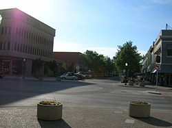
Downtown Twin Falls. Idaho
The deficit of water can easily be measured. The stream gaging station at Twin Falls averages about 3,530 cubic feet per second. At Idaho Falls, just 190 miles (310 kilometers) upstream, the flow can be measured at 5,911 cubic feet per second.
The average flow just below the Milner Dam, a mere 24 miles upstream, is just 884 cubic feet per second and frequently hits zero discharge in the late summer and fall.
This results in the local canyon springs, being the main source of water during the summer, for the spectacle at Shoshone Falls. That is why a spring visit is crucial, for experiencing the falls when their optimum effect can be viewed.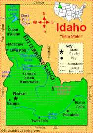
The highest flow of water ever recorded at Twin Falls was 32,200 cubic feet per second, all the way back in June of 1914. The lowest recorded to date was 303 cubic feet per second, on April 01, 2013.
On a monthly basis, June witnesses the highest average flows at 6,280 cubic feet per second. August bring the lowest numbers, at only 956 cubic feet per second.
In 2015, Idaho Power finally initiated the Shoshone Falls Expansion Project. This involved reconstructing portions of the Shoshone Falls Dam, to reduce its aesthetic impact on the area.
In addition, it directed low water releases to the most scenic part of the falls, mainly the Bridal Veil Falls on the north bank of the river.
Location
Shoshone Falls is located at Falls Avenue 3300 East, Twin Falls, Idaho 83301. Phone numbers are (208) 736-2265 and (208) 736-2266.
The electronic contact is https://visitsouthidaho.com/adventure/shoshone-falls/
There is a park overlooking the Shoshone Falls, that is owned and operated by the City of Twin Falls. It encompasses the south bank of the Snake River at the falls.
Season passes can be purchased at $25.00 and are available at the Parks and Recreation Department building and the ticket booth at Shoshone Falls.
The park includes an overlook, interpretive displays and a trail system along the south rim of the Snake River Canyon. The trails provide access to a number of points of interest, including Dierkes Lake and Evil Knievel’s jump site.
About 250,000 to 300,000 vehicles enter the park annually.
Amenities Include a boat launch to Snake River, 11 grills, a drinking fountain, a concession stand, picnic tables, restrooms, and the overlook of the falls as well as the nature trails.
How To Get There
Visitors will arrive by using Interstate 84, turning south on Route 93 and crossing the Snake River by using the Perrine Bridge. Continue on 93 also known as the Blue Lakes Boulevard North into the City of Twin Falls. Take a left on Falls Avenue East for 3 miles and another left at 3300 East Road. Drive for 0.9 miles. This will run directly to the park and canyon about 1.1 miles further on.
Shoshone Falls is located about 130 miles east of Boise, Idaho. It will take about a two hour car drive on Interstate 84, to reach your destination. It is about 113 miles west from Pocatello, Idaho. It will take about 1:45 hours to reach the falls by I-86 and I-84.
One can also use the Magic Valley Regional Airport, located about 5 miles south of Twin Falls.

Marcello Arrambide considers himself a fanatical entrepreneur. During his younger years, when CD burning software first came out, he burned CD’s and sold them for $5 to $10 a piece, worked at a bakery and took the leftovers to school and sold them to students for breakfast the next morning. He flew to New York City and found a contact in China to have purses and wallets shipped him directly to sell.
He has since tried sales, real estate, software and day trading, where he coaches others to learn and develop their skill in the market. He plans to show everyone how easy living and moving overseas can be on your own terms as long as you have high speed internet and a computer.