I packed my down coat rather skeptically – but on day 3 of my Oman hiking trip I found myself eagerly unpacking it and putting it on – in addition to my gloves! When you think of the Middle East – you probably don’t think of mountain ranges and freezing temperatures. However it was the mountain ranges of Oman that I found the most fascinating part of my travels.
The Al Hajar mountain range located in the Northeast of Oman serve not only as the agricultural hub for the country, but historically it was the geographic barrier that kept Oman free from invasions. Historically this region is also where some of the largest battles were fought in Oman’s quest for unity. Today the government has thrown large investment into the development of this area especially in the area of road construction. The road we took up into the mountains was new and spectacularly created – full of hairpin turns and steep climbs – this was not for the carsickness prone!
For me, the Al Hajar range served as my playground for 4 days of my Oman mountain trekking tour, as well as a photographic muse. We hiked in the warm temperatures during the day around Jebel Akhdar and Jebel Shams, and then would set up camp and prepare for the temps to drop to freezing as the sun went down. Most of the hikes do require a guide and you will also need a 4×4 to get to many of these locations.
Balcony Hike – An Nakhr Balcony
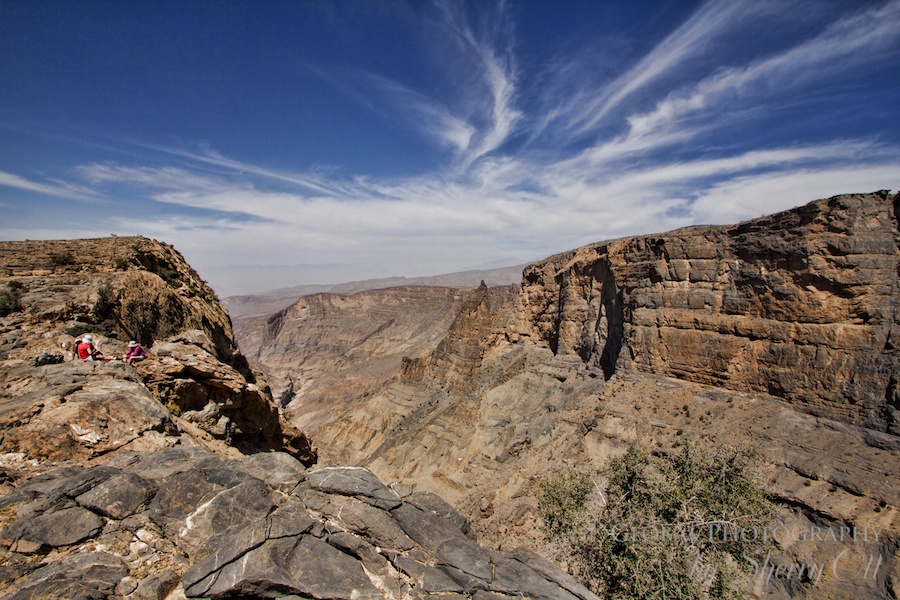
It’s referred to as Oman’s Grand Canyon – located on Jebel Shams (mountain of sun). Jebel Shams is the highest mountain in Oman (and eastern Arabia) at 9,800 ft and is part of the Al Hajar range. The Balcony Walk (An Nakhr Balcony) is a well-marked trail that runs the rim of the canyon. This 4 hour out and back hike will dish up some of the best views in Oman. You will pass by abandoned villages and find hidden waterfalls. Plus, I can guarantee you’ll have a few daring goats following you along the way hoping you may drop a snack! The hike was moderate, and at times narrow if you are scared of heights like me – but it can be done in tennis shoes as there is no real technical trekking required.
Military Training Hike
As our guide, Rob, briefed us on the hike we’d be doing the next day and described it as an old military training route – I should have known that it would be challenging. This was an actual trail of sorts, but it was not marked very well and so a guide is a necessity. There were occasional purple splashes of paint along the rocks/trails that revealed the route for the military recruits – but not really a good enough bread crumb trail for civilian tourists like me. Rob led us down wadis into little villages, across dams, over high plateaus, and along the rim of steep canyons. It was a challenging 5 ½ hour hiking day, but the views were worth it. My favorite part of the day was our lunch spot – perched high up on a ledge with a view to the valleys below.
Abandoned Villages
We took off from camp and blazed our own trail through the heart of the Western Hajar mountains. After a few hours of walking on top of the cliffs enjoying the cool air and expansive views, we dropped down into the wadi via some old steps and into two abandoned villages. The village located in wadi Bani Habib were crumbling – but they did give us an idea of what village life used to be like not that long ago. These villages were abandoned not do to fighting, but due to progress. As Oman started develop in the mid eighties, the Sultan had schools and roads built in strategic locations. As villagers in the wadis wanted to send their kids to school and have access to roads, many of the villagers ended up moving closer to the schools forming new villages in easier to reach locations. Many of the towns in Oman are quite young, and as development and tourism continues, they continue to experience growth. A guide was required for the hiking we did, however you can easily visit the old abandoned villages by car and a small walk down into the wadi on nicely created steps for tourists.


Smelling the Roses Village Hike
The Jebel Akhdar, meaning (The Green Mountain), surpringly provided some lush, terraced landscapes to hike through. Due to Jebel Akhdar’s location and unique weather, the Green Mountain produces a variety of fruits, but it also produces some essence which proves to be quite valuable. Rose bushes dot the terraced mountains of Jebel Akdar! Rose water essence is produced and sold locally as well as exported throughout the UAE – Oman rose water is big business in this area. Seeing the levels and levels of pink rose bushes perched on the terraces with a backdrop of jagged brown mountains was a sight to behold. This is why one of my favorite hikes we did was through villages (Al Aqar & Al Ayn) following the filajes (irrigation canals) and the terraces. Villagers were out harvesting the roses, the air was fresh and rose filled, the views were spectacular, and the hiking was steep. This was one of the few times where we really came in contact with the locals and could see how they lived and worked.
Disclosure: While in Oman I was a guest of Exodus Travels on their Oman Hiking Tour. However, all of the opinions expressed here are my own.

Sherry Ott is a refugee from corporate IT who is now a long term traveler, blogger, and photographer. She’s a co-founder of Briefcasetobackpack.com, a website offering career break travel inspiration and advice.
Additionally, she runs an around the world travel blog writing about her travel and expat adventures at Ottsworld.com.com.