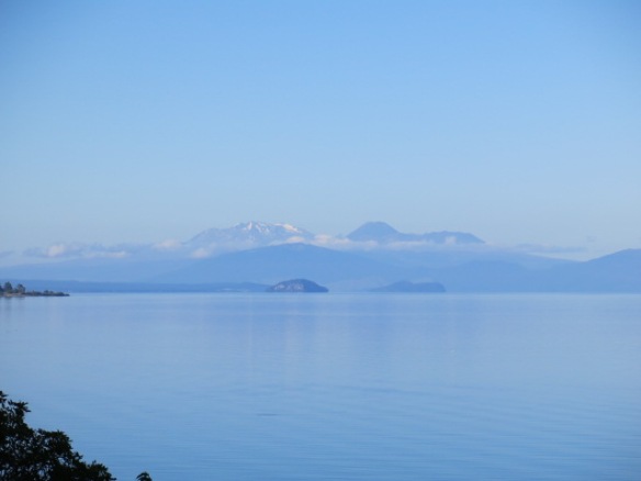
Mounts Tongiriro & Ngaruhoe loom over Lake Taupo. Mt. Ruapehu (below) is the third active volcano overlooking the lake.
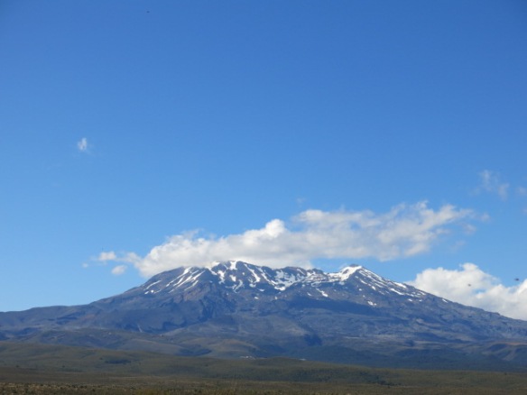
Mt. Ruapehu, the highest mountain on New Zealand’s North Island. The multi-crested volcano holds snow on its peaks year round.
Lake Taupo sits astride New Zealand’s most active geothermal area. That’s inferring quite a bit of geothermal “activity” considering New Zealand is a land of earthquakes, volcanoes, geysers, boiling mud holes, and steaming pools and vents. In fact, Lake Taupo is the caldera of extinct Mt. Oruanui which, when it last erupted 26,500 years ago, was the largest volcanic eruption ever. One guide states, Oruanui made Krakatoa “look like a pimple.” In its last explosion in 180 AD, red skies resulting from the sheer volume of ejected volcanic ash were noted in both Rome and China.
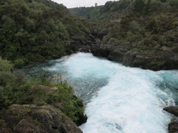
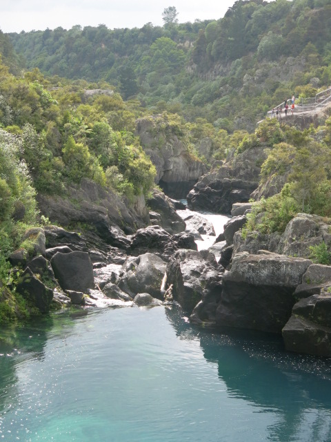
The Waikato River, NZ’s longest, flows from Lake Taupo (pronounced “toe-paw”). One of the first gorges the river winds through produces the magnificent Huka Falls, a stunnning turquoise 10 meter blue cascade that surges through the narrow chasm at a rate of 200,000 liters per second.

Huka Falls flows through this narrow gorge at 200,000 liters of water per second.

Looking down river through the narrow gorge forming the bottleneck creating Huka Falls.

The brilliant color is a combination of glacier melt and sediment from pumice stone.
We spent a day in Tongoriro National Park, New Zealand’s first national park, and named after the multi-coned volcano of the same name. Mt. Tongoriro (1967 m.) is an active volcano which blasted away (more like volcanic spurts — nothing to sneeze at) in 2012. Neighboring, single-coned Mt. Ngauruhoe (2297 m.) which erupted 45 times in the 20th century, most recently in 1974-5 for 11 months continuously. The volcano is most famous, however, as “Mt. Doom” in Kiwi native Peter Jackson’s Lord of the Rings movie trilogy. the tallest of this volcanic trio is Mt. Ruapehu (2797 m.), one of the world’s most active volcanoes. Ruapehu last burped in 1973, but is most famous for its disastrous eruption on Christmas Eve, 1953, when the volcano blew, causing a massive lahar (volcanic mud flow) down; its sides, sweeping away all in its path, including a railway bridge. Moments later a passenger train unable to stop, flew off the mountain side into a river gorge below, killing 153 holidaymakers on board.
Testing our luck and the fates, we decided to ride the chair lift up Mt. Ruapehu:

The lower level chair lift ascending Mt. Ruapehu. The mountain side below is strewn with scoira, or volcanic lava rock. The multiple volcanic cones of the mountain loom above.

Impressive views of Mt. Doom in the foreground, and Mt. Tongoriro, behind.
There is a spectacular Crater Lake further up Mt. Ruapehu, but we were unable to make the 3-4 hour hike up from the last chair lift stop on the mountain. We spent the day walking or driving around various parts of the park, taking shorter hikes. No matter the angle, the views of these three volcanoes is stunning. As we were leaving, I spied a stream of steam rising from one of the flanks of Mt. Ruapehu:
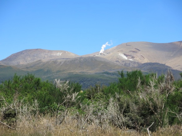
Yup — Mt. Ruapehu is still kicking — and steaming. I viewed this as a farewell venting from the volcano, just letting us know we were lucky that day!
Back at Lake Taupo, we visited the Aratiatia hydroelectric dam and gorge. The dam holds back the mighty Waikato River to cull some of its hydro power into electricity for the region. Because of the sheer volume of water, the engineers open the sluice gates several times a day, creating brief but powerful waterfalls and surges, filling the rocky gorge below the dam with spectacular rapids for several minutes before closing the gates again.

The sluice gates at the Aratitia Dam before opening.

The rocky gorge beyond the dam. Note how the gorge looks impassable due to the numerous, tall rocks.
About 10 minutes since the gates were opened, the rising water has come partway up the gorge.

The gorge is nearly full, and the river’s surge is still flowing.

The gorge is nearly filled….

About 15 minutes after the gates opened, the gorge has filled and begun to empty again.
Twenty minutes later, the waters have almost entirely receded, only to start the cycle again in another hour or so.
The highly active geothermal zone on the North Island runs from the Lake Taupo area northwest through Rotorua to White Island off shore in the Bay of Plenty. We chose to stay in the Lake Taupo area for several days because of the sheer beauty of the lake and mountains. We paid a nominal visit to Rotorua, the “hot spot” of the North Island, just to check it out. Broadly commercialized and lacking any interest for us, we walked around the town a bit, just to see some of the vents and mud pits, then left. However, there are a number of geothermal “parks” (read natural geysers, vents, mud pools, etc.) which are available for tourists to visit; most have some sort of “draw,” such as “cultural” event featuring a Maori haka (dance) or hangi (traditional feast) to supplement the natural, geothermal sights. Just a sample of what we saw in Rotorua:
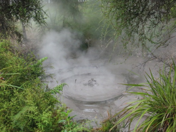
Boiling mud hole in Rotorua.

Steam rising from a thermal pool.
The Taupo region is filled with spectacular scenery and great geothermal activity. The area is considered highly unstable because of this geothermal zone, but, so is the rest of the country. New Zealand takes these threats seriously: museums in both Auckland and Wellington have extensive exhibits educating people about the causes and effects of this underlying geothermal activity. Each had “interactive” exhibits demonstration the sights, sounds and feels of a volcanic eruption or an earthquake. Visitor centers and restrooms in the Taupo area displayed posters of what to do if an eruption occurred.
The dangers of living in New Zealand are real. Christchurch, on the South Island, suffered two major earthquakes in 2010 and 2011, the latter of which caused massive destruction and killed 185 people. Of the 2500 commercial buildings then in Christchurch, about 1700 either were destroyed in the 2011 quake or subsequently torn down due to the accumulate3d structural instability. The severity of the first earthquake in 2010 substantially contributed to the structural collapse and loss of life in the second, 2011 earthquake. The city still, five years later, has unbuilt-upon city blocks a”buildings.”

Five years after two earthquakes in 6 months, Christchurch still has many empty lots where buildings once stood.
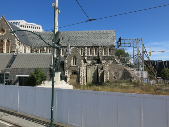
The Anglican Cathedral remains boarded up as the city decides whether to try to save the structure or tear it down.
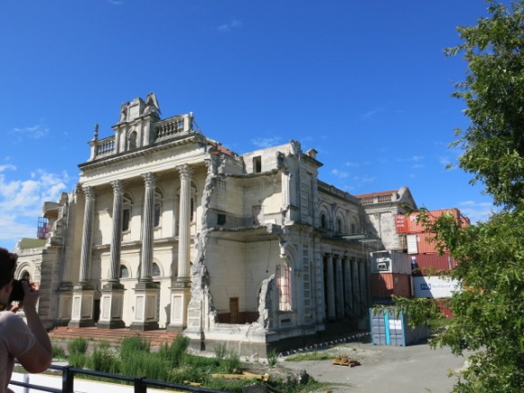
The Catholic church has only recently decided to rebuild its cathedral.
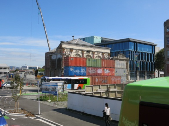
Shipping contI
On February 15 — just one day after we left Christchurch — the already traumatized city suffered a 5.7 earthquake. Thankfully, no one died (although several were injured) primarily because the quake hit 15 km east of the city and on a beautiful Sunday when people were out of offices and homes. Nevertheless, the earthquake was powerful and violent enough to cause nearby cliffs to collapse.
The constant threat and occurrences of such natural disasters obviously hasn’t caused most Kiwis to leave their homes nor prevented tourists such as ourselves from visiting the region. For us, the beauty far surpasses the risk — for now. But these quakes and shakes of the land remind us that natural beauty also comes with nature’s cost.
![]()

Carol Barbier Rolnick grew up in Japan and Southeast Asia, traveling extensively as a child through Asia, the Mideast and Europe on family vacations. Travel has continued as a priority through raising kids and continuing into retirement, extending adventures through the Americas, southern Africa, Asia, and repeat trips throughout Europe. Carol and her husband, Michael spent four summers based in Utrecht, The Netherlands, which has become like a second home. They are (still) aiming towards Australia-New Zealand and Antarctica to round off their continental travels.